
Apple Maps launches enhanced experience for India with 3D landmarks
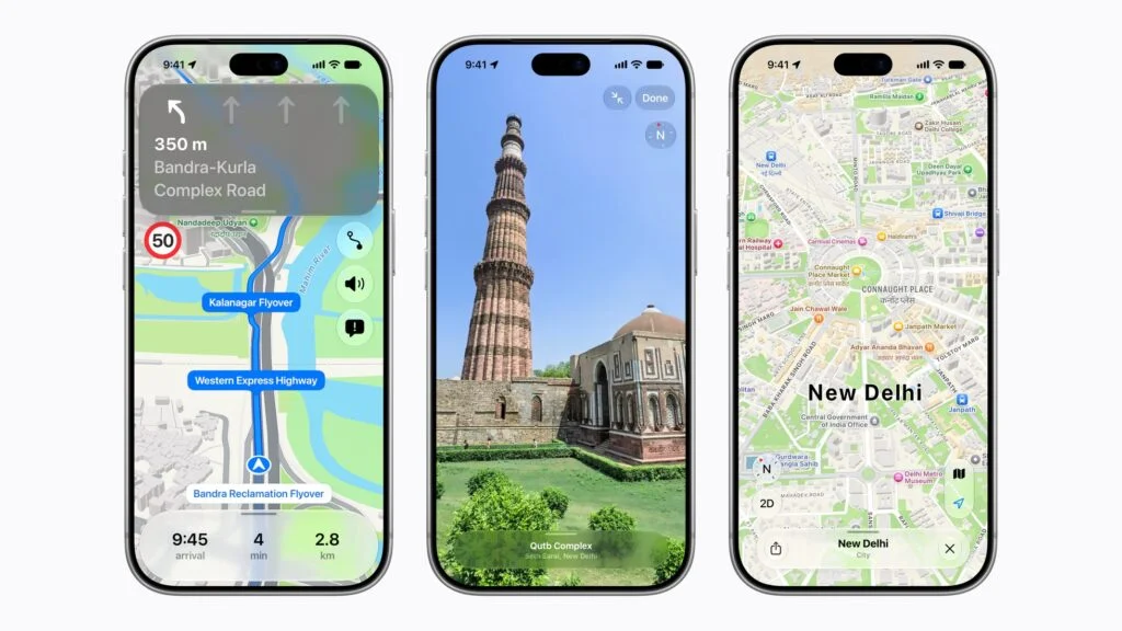
Maps now offers better navigation, three-dimensional landmarks, and Look Around, plus enhanced Natural Language Guidance and dual-language labels built for India.
Today, Apple announced users can now access an all-new Apple Maps experience for India. With faster, more accurate navigation; comprehensive views of roads, buildings, parks, and shopping centres; and over 300 three-dimensional landmarks, planning any journey is easier and more seamless. Features built specifically for India, such as enhanced Natural Language Guidance and dual-language labels, help users navigate local cities and towns.1
“Apple Maps is the best way to explore and navigate the world, and we are excited to bring an enhanced Maps experience to even more users with today’s rollout of the new map in India,” said Max Muller, Apple’s vice president of Apple Maps. “The new map offers some of our users’ favourite features like Look Around and AR Walking Directions, but we’ve also designed the map for India’s specific navigation needs, including enhanced Natural Language Guidance and customised dual-language labels, making it easier than ever for users to find the places they love and get to where they’re going.”
A New Navigation Experience Built for India
The new Apple Maps in India helps users more easily navigate and explore the world. Natural Language Guidance offers directions that sound more conversational and are even easier to follow, such as “At the next traffic light, turn left.” In India, Apple has enhanced the feature to be more useful and relevant by adding real-world details, such as pillars and other points of interest, that help users find their way along roads that may have no names, with directions like “Turn right after the petrol pump.”
Lane guidance helps users identify the correct lane before they need to turn or enter an elevated road. And with multi-stop routing, users can plan up to 15 stops in advance, and when they’re ready to go, the routes automatically sync from Mac and iPad to iPhone.
Many signs across India show both English and a local language, so dual-language labels in Maps are based on the language a user’s device is set to and the local language of a region. For example, a user with their device set to English will see labels in both Hindi and English when viewing the Delhi area, and Marathi and English when looking at Mumbai. Maps supports English and Hindi, and has added support for Bengali, Gujarati, Kannada, Malayalam, Marathi, Tamil, Telugu, Punjabi, Odia, and Urdu.
Users can also share an estimated time of arrival with family and friends, with a simple tap using Share ETA. Recipients can follow the journey, and Maps will update them with a revised estimate for arrival time if a significant delay occurs. Users can also safely and easily report an accident, hazard, or speed check along their route by letting Siri AI know “There’s an accident up ahead” or “There is something on the road.” Users can even report when incidents displayed on the map have been cleared, all while keeping their focus on the road. And for drivers of certain electric vehicles, Maps can help plan trips that include stops for charging by analysing elevation changes and other factors along a route.
Transit riders in Ahmedabad, Bengaluru, Chennai, Delhi, Hyderabad, Kolkata, Mumbai, and Pune, as well as on Indian Railways, can use Maps to plan their journeys, find nearby transit stations, and pin their favourite routes. Riders will also receive notifications when it’s time to get off at their stop.
Explore with Look Around
Maps in India now also offers interactive street-level imagery, with high-resolution 3D photography and smooth and seamless transitions with Look Around. Now users anywhere in the world can explore with Look Around in India.
AR Walking Directions
Users can now get step-by-step walking guidance in augmented reality. Users can simply raise their iPhone to scan buildings in the area, and Maps generates a highly accurate position to deliver detailed directions that can be viewed in the context of the real world.
Additional features in Maps include:
- Cycling directions provide users with important information about their ride, including elevation details, as well as callouts for bike lanes or stairs.
- Custom Route Creation enables users to draw a path along trails or roads and save it as a custom route.
- Preferred Routes helps users keep track of their commutes, all while protecting user privacy. iPhone uses on-device intelligence to learn and understand the routes users take between the places they frequently visit, like home and work, and will show a preview of their commute so they know what to expect before they leave.
Maps helps millions of people in over 200 countries and regions navigate and explore the world. Maps can be anywhere users are: at home, in the office, or on the go with iPhone, iPad, Mac, and Apple Watch; and in the car with CarPlay. Maps is deeply integrated into the most popular apps customers use every day, including Photos, Messages, Calendar, and Weather. With MapKit and MapKit JS, Maps is also the foundation for thousands of third-party apps and services.
Maps and Privacy
Apple is committed to keeping personal information safe and has built privacy into the core of Maps. With Maps, no sign-in is required. Personalised features, such as suggested departure time to make the next appointment, are created using on-device intelligence. Any data collected by Maps while using the app, including search terms, navigation routing, and traffic information, is associated with random identifiers that regularly reset to prevent connecting search and location data stored on the server to an identifiable user. Maps goes even further to obscure a user’s location on Apple servers when searching for a location through a process called “fuzzing.” Maps converts the precise location where the search originated to a less-exact one within 24 hours.
- Dual-language labels and enhanced Natural Language Guidance are available in Apple Maps on iOS 27.2, iPadOS 27.2, watchOS 27.2, and macOS 27.2 or later.